Countdown to Earth Day
April 13, 2004
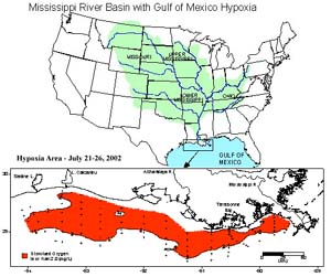
Image source: NOAA
Every spring a disturbing and frightening feature develops in the Gulf of Mexico off the coast of Louisiana and Texas. As nutrient-rich waters enter the Gulf from the Mississippi and Atchafalaya Rivers, they cause a tremendous “bloom” of algae along the coast. The rapid algae growth in turn uses up the available supply of oxygen in the water, forcing other creatures to flee or die. As the algae dies and sinks to the sea bottom, its decomposition uses up more oxygen, killing in the process any bottom-dwelling organisms -like shrimp. The greatly lowered oxygen conditions last until the fall when tropical storms and hurricanes mix the waters.
Scientists term this type of phenomenon an “hypoxia zone”. To local fishermen, it’s the Gulf of Mexico “Dead Zone”.
Seasonal hypoxic conditions in the Gulf were first recorded in the 1970s when the phenomenon occurred every two to three years. Then it became an annual event, and the zone of death kept expanding. Between 1985 and 1992, the zone averaged 3,200 square miles, officials said. Between 1993 and 2001, the area doubled to an average size of 6,200 square miles. In 2001, the zone reached a record size of 8,006 square miles, larger than the State of Massachusetts.
The cause of the Hypoxia Zone has been shown to be excessive fertilizer use throughout the Mississippi River Basin. The land area drained by the Mississippi contains 47% of the U.S. rural population, and 52% of its farms. Since the 1960s fertilizer use in the American heartland has increased by over two million metric tons per year. Over the same time period, the flow of the Mississippi has been increasingly confined to keep it from naturally flooding its banks - which would disperse its nutrient load.
How do you correct a situation that has such dire consequences, but for which th cause is so dispersed? One of the most difficult problems has been convincing farmers in Iowa and Illinois that their agricultural practices are causing the destruction of an ecosystem and a fisheries economy a thousand miles away.
Progress is being made, however, as the states within the Mississippi Basin work together and with the Federal Government on a plan to control the timing, amount and methods of fertilizer application by farmers in the region. In 2003, the measured Hypoxia Zone had shrunk to 3,300 square miles. Such controls will have local benefits as well in reducing the amount of farm chemicals which have contaminated major sections of drinking water aquifers in several states.
A nice multi-media tutorial on the Hypoxia Zone is available from the Science museum of Minnesota at:
CENR. 2000. Integrated Assessment of Hypoxia in the Northern Gulf of Mexico. National Science and Technology Council Committee on Environment and Natural Resources, Washington, DC. is available online at: http://www.nos.noaa.gov/products/pubs_hypox.html
Get more information about the U.S. EPA’s program to improve the water quality in the Mississippi River basin and the Gulf of Mexico at: